bbbbbbbbbb Documentation at Coldwater Cave

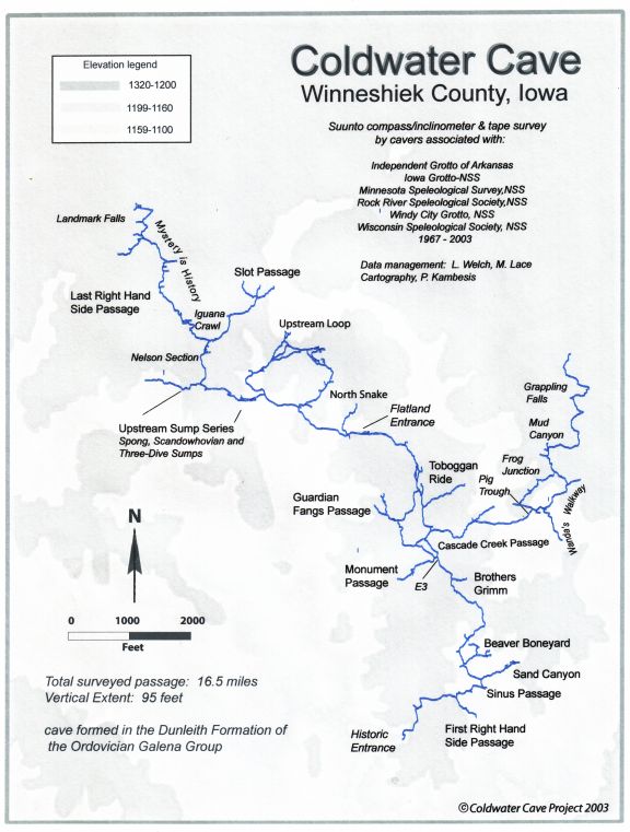
Survey, Resurvey and Inventories

Project mapping efforts at Coldwater Cave have always been conducted with the "survey-as-you-go" approach. Current survey standards strive for quality control on data collection and recording as much survey and resource inventory data as possible. It is important to know more about the cave besides where it "goes". A good detailed sketch serves as an illustrative resource inventory of the cave and its features. Vertical control, detailed cross sections and profiles where appropriate provide information for geologic and hydrologic research and for exploration. Assuring completeness and accuracy in passage dimensions and other dimensional features is important as computer technology allows us to do much more with the survey data in terms of cartographic displays and various graphic representations that enhance understanding of the cave.


A survey team re-mapping a section of downstream passage, photo: M. Bounk


Quite a bit of resurvey has been done which is typical for long-term mapping projects. The reason for resurvey is because since the late seventies, survey standards have changed dramatically. Today's standards include doing backsites for quality control on the survey line, including clinometer readings at every station (for vertical control), and sketching-to-scale. The resurvey effort has paid off not only with the collection of more accurate and detailed data, but also with the bonus of new passage previously overlooked in all areas of the cave.

Mike Lace and Larry Welch oversee the task of making sure that all surveys meet current standards. Lace concentrates on cartography while Welch focuses on data management. John Lovaas has added a GIS component to the cartographic representation of the cave which higlights surface and subsurface relationships.

As any long-term project member knows, an up-to-date survey serves as a proven guide for exploration, and effective management of the survey data has accelerated recent exploration and science in Coldwater Cave. Among upcoming cartographic objectives are updated maps of the cave for display, research and conservation.


Plan view of Coldwater Cave


DEM of Coldwater Cave area showing profile from
Coldwater Creek to Pine Creek drainages


Profile view of Coldwater Cave


Photographic Documentation and Photomonitoring

Photography is an important part of any exploration for it is only through visual images that a sense of the cave can be truly conveyed. For the past 17 years, Scott Dankof (IA) has been carefully documenting all areas of the cave. Dankof, whose cave images have garnered many awards at the NSS Photo Salon, not only shoots photos of the pretties, he also photodocuments restored areas, and other significant features of the cave. At the other end of the photography spectrum is Mark Jones who with his endless supply of disposable cameras has managed to take some decent photos of exploration efforts in extremely remote areas of the cave where no one has yet dared to take "real " photo equipment. Others who have participated in photodocumentation in the cave include John Lovaas, Ed Klausner and Mike Lace. See the Photo Gallery for examples of photodocumentation in Coldwater Cave.

Historic Documentation

A detailed historical log was compiled of all the Project work, including the discovery of the cave, by drawing on firsthand accounts from principal contributors since the cave's discovery in 1967. The log is continually updated and functions as an important resource tool in historical documentation, and monitoring traffic and its impact on the cave. From the current log (which has records for 872 individual trips into the cave as of March 2003), its been documented that 60% of all trips have been for exploration/survey, 20% for casual touring, 10% for photodocumentation and 10% for research and restoration.

Home || Coldwater Cave Project || Exploration History || Conservation & Restoration || Cave Documentation || Research || Safety || Photo Gallery || Links

copyright 2003 (C) Coldwater Cave Project