Caving at its best in the Upper Midwest Photos by Scott Dankof NSS News December 2003
|
 |
Caving at its best in the Upper Midwest Photos by Scott Dankof NSS News December 2003
|
|
The exploration and documentation of a significant cave system is a long-term endeavor that requires serious commitment in time and resources. After a big breakthrough the first waves of exploration reveal those parts of the cave that are easy to access or that do not require out-of-the ordinary logistics or techniques. But pushing a cave to its extreme boundaries, finding the not-so obvious, and learning the cave on its own terms can often take many years. Coldwater Cave is one such example. Its exploration and documentation have spanned more than three decades, through the efforts of three generations of cavers.
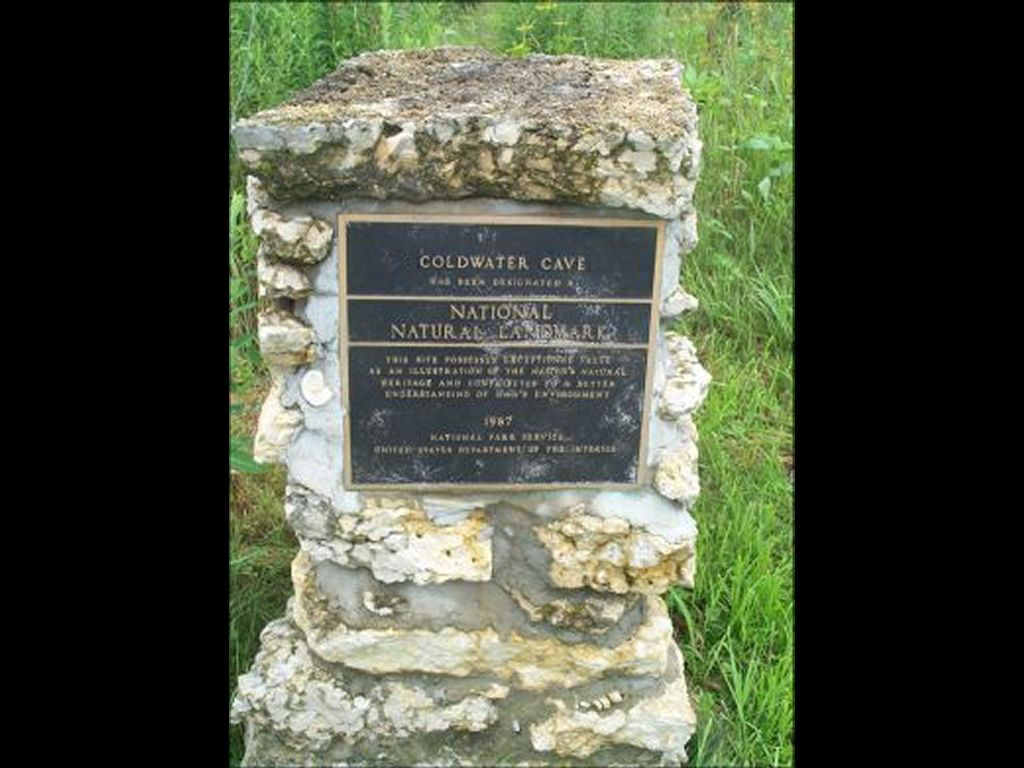
Coldwater Cave is by far the most significant cave in the Upper Midwest. In December of 1987 it was designated a National Natural Landmark by the U.S. Department of the Interior. This status is accorded to geologic and ecologic features considered to be of national significance.
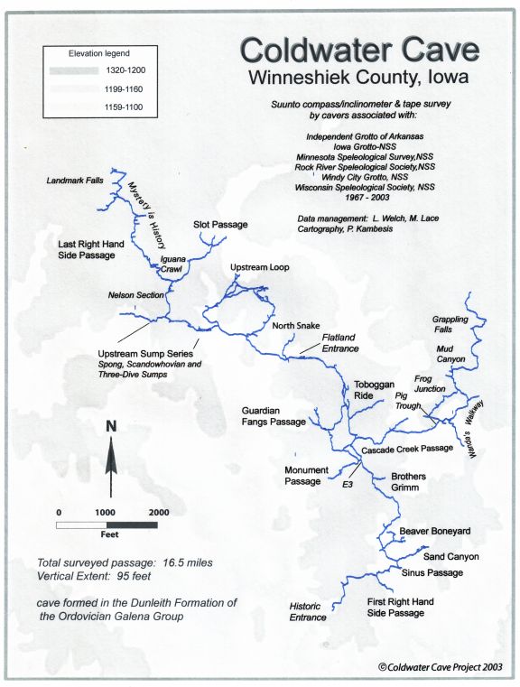
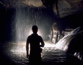
The cave system is part of a fluvio-karst drainage basin located in northeast Winneshiek County, Iowa and southern Fillmore County, Minnesota. The cave proper is situated in the Iowa part of that basin. Formed almost entirely within the cherty carbonate sequence of the Dunleith Member of the Galena Formation (Ordovician) the cave consists of over 4 miles of borehole stream passage, nearly a mile of parallel stream passage and another 11 miles of infeeders and their associated offshoots. There are over one hundred domes within the cave system, most of which are hydrologically active and a few which contain significant waterfalls. The cave system, which is dendritic in its layout, is developed within a very subtle carbonate ridge mantled with loess and glacial till.
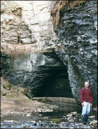
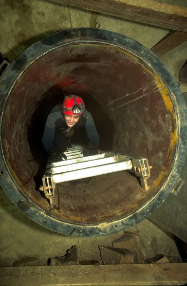
There is only one natural entrance (Historic Entrance) to the cave and it is a water-filled spring that issues from the base of a 100 foot-tall bluff. Access to the Historic Entrance requires SCUBA and the underwater entrance is currently gated. The system also consists of two other springs and two paleo springs which are not humanly enterable. Access to the cave is through a 94-foot shaft (Flatland Entrance) that was drilled by the State of Iowa for researcher access in the early seventies. The Flatland Entrance is owned by Ken and Wanda Flatland. Independent of the Coldwater Project, a second privately owned shaft entrance was drilled in 2003, and is located approximately 1 mile downstream from the Flatland Entrance.
From the late sixties through the summer of 2003, over 16 miles of passages have been discovered and mapped and potential exists to find more. It should be noted that the ōrateö of exploration is dictated not by the remoteness of the cave entrance or by extreme human endurance barriers. . Rather it is the cave itself with its multiple sumps, extreme variations in water temperature, responsiveness of stream levels to rainfall and snow melt, and seasonally high levels of carbon dioxide with corresponding low levels of oxygen, that determine where and when exploration progress is made.
Natural National Monument plaque
In the Beginningģ
Explorations in Coldwater Cave began in 1967 when Iowa Grotto caver Steve Barnett free dove the 47 degree F stream issuing from Coldwater Spring ¢ one of many springs that drain the karst lands of northeast Iowa. Donning wetsuit and scuba gear Barnett returned with fellow grotto member Dave Jagnow and together they found their way through 2000 feet of mostly underwater conduit which eventually emerged in air filled passage. During the next two years, Barnett and Jagnow, joined by Tom Eggert, discovered and explored over 3 miles of magnificent stream gallery and thousands of feet of side passages of much lesser dimensions. On a 52-hour trip they ran a survey line from the spring entrance to an upstream sump ¢ a 3.5 mile traverse.
Barnett and Jagnow recognized the significance of their discovery and set out to take measures to protect and preserve Coldwater Cave. They presented their find to the Iowa State Conservation Commission in December of 1969. The state took a lease on a portion of land above the cave from June 1971 through January 1975. This constituted a hiatus in cave exploration and mapping while the Iowa Geological Survey conducted and supervised various projects and studies.
Since the only entrance to the cave was through submerged passages, the state drilled a 94 foot deep, 30 inch diameter shaft and built a wooden platform in the stream to provide access to researchers. Hydrologic parameters were monitored to study pollution levels and detailed records were kept on atmospheric C02 and 02 variations. The atmospheric results showed that at times, C02 concentrations exceeded safety standards set by the Bureau of Mines and Standards, and 02 concentrations could be less than the minimum safe levels. Because human activity within the cave was minimal, faunal and floral studies were conducted by Grinnell College aimed at establishing a pre-human contact ecological baseline. Research on speleothems, isotopic dates, and climatic interpretations was pursued. A theodolite survey was conducted which documented a little over a mile of cave passage. However, despite the tremendous enthusiasm that the cave generated at that time, the state of Iowa could not justify a large expenditure of money for the projected cost of commercial development.
Spring entrance to Coldwater Cave
Shaft entrance to Coldwater Cave,In January of 1975 the stateÆs lease expired and the cave entrance, plus ōimprovementsö, reverted to the landowners Ken and Wanda Flatland. The State offered to seal the shaft if the Flatlands requested it. Fortunately the owners wished to continue to offer access to this truly unique cave. Their willingness and desire to open the cave for continued exploration, survey and study brought in the next generation of cavers and the establishment of the Coldwater Cave Project.
As most true explorers are apt to do, Barnett and Jagnow speculated on the potential of their new find and passed those speculations on to the next generation of Coldwater explorers. Many of the domes encountered during early explorations appeared to have open leads near their tops, eliciting the speculation of an extensive upper level. With one exception, most all of the side passages that feed the main stream conduit do so from the east and just about all carry water. Observations of a drainage divide in at least one of these infeeders introduced the possibility of a parallel cave system. And initial reconnaissance of the terminal upstream sump, located over 3 miles from the spring entrance, indicated that the bulk volume of water in the cave originated from uncharted passages, possibly heading north. For the next 28 years, these speculations on potential inspired and drove the succeeding generations of explorers to push the limits of Coldwater Cave.
Coldwater Project explorations: 1976 - 1986
From 1976 through 1986 Coldwater Project cavers from Iowa, Illinois, Minnesota, Wisconsin, and Arkansas pushed back the boundaries of known cave. Mapping trips to many small, miserable side passages slowly increased total survey footage. Digging projects were initiated in downstream infeeders including Sand Canyon and Monument Passage. New leads were noted and old ones were scrutinized with new enthusiasm.
As explorations proceeded, more domes were discovered, some with promising climbing leads. However, attempts at reaching an upper level via any of these leads were unsuccessful, not in terms of the climbing attempts, but because the cave did not ōcooperateö. Though high leads were reached, they always ended in short order either in flowstone or breakdown. A few of the domes contained active waterfalls which were impossible to negotiate due to the force of the water. By 1980, the cave had been surveyed to just over 7 miles and a map published in Caving International (No. 8, July 1980).
In the early eighties, Coldwater Project cavers succeeded in breaching a drainage divide in the Cascade Creek Passage and getting into WandaÆs Walkway, a stream trend that appeared to parallel ColdwaterÆs main passage. A major infeeder, Grappling Falls, was climbed and going passage noted. However, a combination of high CO2, faulty equipment and just plain bad luck prevented much progress in this area of cave. The results from hydrologic studies conducted by Betty Wheeler in 1986-87 proved that there was indeed a parallel system to Coldwater Cave and during base flow conditions, its waters resurged at Carolan Spring, located a mile or so east of Coldwater Spring.
Though gains were made in negotiating the Spong Siphon, the beginning of the upstream sump series, no one had yet succeeded in really cracking the north side of the cave. Despite this, Coldwater Project cavers broke 10 miles of survey in December of 1986 and an updated map was published in the NSS News (Vol. 46, No. 6) in 1988.
A New Generation: 1987¢present
In order for a long-term caving project to persist, it needs an ongoing and continuous supply of fresh blood. The late-eighties and beyond saw the induction of many new cavers to the Coldwater Project and their enthusiasm renewed the interest and activity of some of the ōoldtimersö. From 1987 through the present, aggressive attempts on upper leads, pursuit of the parallel system, and hard pushes on the upstream sumps brought the realizations of Coldwater CavesÆ true potential to a new level. These explorations also taught us a lot about the geologic and hydrologic nature of the cave ¢ and where cave passages may or may not go in terms of human accessibility.
Since the beginning of 1987, over 550 work trips have been logged in Coldwater Cave encompassing exploration and survey, photography, restoration, research and rescue training. ItÆs not practical to summarize all of the trips but the highlights of this generationÆs work are summarized in the following paragraphs.
The Mythical Upper Level:
One of the most prevalent legends in Coldwater Cave explorations has been the existence of an extensive upper level, one that might reside above currently accessible cave passages. Steve BarnettÆs early reports of a subway-sized corridor at the top of a dome in the First Right Hand Side Passage launched that legend. The discovery of many other domes throughout the cave with what appeared to be upper leads kept the legend alive for years. As the use of electric lights became prevalent, those dark shadows cast by the soft glow of carbide gave way to blind alcoves, including the subway sized lead first reported by Barnett. In turn, the tops of those domes that appeared ōlead-lessö showed much more promise through the focused beam of electric light.
On those remaining upper leads came assaults with climbing poles, grappling hooks, bolts, and challenging free climbs which didnÆt turn up much upper level passage. More often than not, low, miserable tubes and some amount of digging in gruesome bellycrawls usually preceded any lead climbing attempts. And the reward for the effort was either breakdown, formation choked fissures, or tight upper canyons that became impassible.
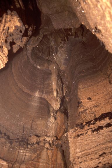
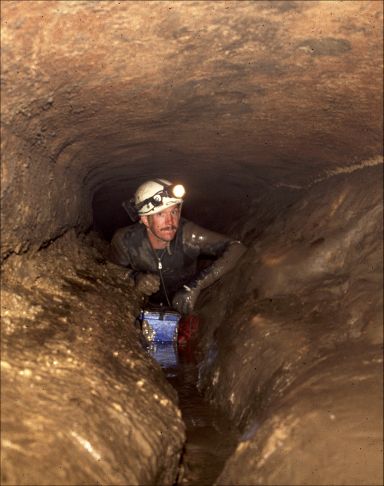
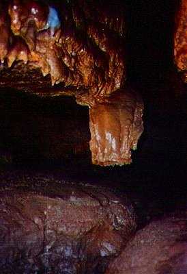
A typical dome in Coldwater Cave is anywhere from 15-70 feet tall and can be circular or elliptical in shape. Most of the domes are hydrologically active and a few contain perennial waterfalls. Dome walls are fluted and water exits through small drains that can take the form of bedrock-lined tubes or low, narrow crawlways coated with thick, goopy mud. Negotiating these dome drains frequently involve flat out bellycrawling in body size tubes causing the inflowing water to dam up in front of the caver.
In 1987, a team made up of Norbert Kox (WI), Scott Dankof (IA), Don Smith (WI), and Randy Kwiatkowski (WI) used a specially designed "self-hanging" ladder to get to a significant climbing lead at the top of a dome in Brothers Grimm Passage. Kox modified a design first used by an Austrian caver. In Kox's version he used cable instead of nylon. Ladder rungs were fit with Į inch EMT couplings, and a hook was made from an S-tine from a farmer's drag. The hook was secured to the ladder by a carabiner, and then plugged into the top rung. Each successive rung was plugged into the next, until the desired height was reached. Once hooked onto the ledge above, the device was pulled down and the ladder successfully rigged. With their innovative ladder, the cavers found a forty-foot high canyon with narrow straight passages reminiscent of the Stewartville Crevices in Mystery Cave, MN. Unfortunately their lead was terminated by flowstone and all they had to show for the effort was 70 feet of upper passage and shredd ed coveralls. They named their find the Tecumseh Passage.
One of the most persistent pursuits of the upper level was undertaken in the Guardian Fang Passage, also known as the Breakdown Passage. This infeeder, located downstream of the entrance shaft was first explored in 1977 by cavers from Minnesota and Illinois and had been checked off and on again for years. From the early to mid-nineties Iowa cavers Mike Nelson, Stacy Cyphert, Mike Lace, Marc Ohms from South Dakota, and Illinois cavers Chris Beck and Larry Welch, and others crawled, dug and surveyed 700 feet of grueling passage which did access about 500 feet of what could be considered upper level. However, the explorers did not find a gateway to any sort of extensive upper tier of passage. What they did find was a complex of muddy, wet infeeders and domes which ended impassibly. If nothing else, the Guardian Fang area proved to be a textbook example of what passages do when they trend away from the heart of a ridge and go toward its edges, their fate being to end in dome complexes.
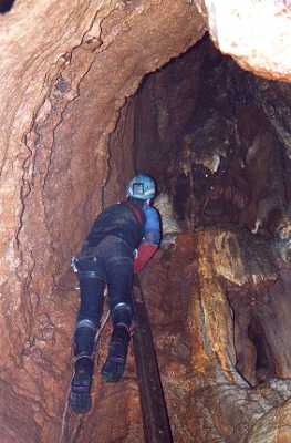
The North Snake passage had always managed to suck in unsuspecting explorers with the promise of domes and going passage. But before the score of any potential booty, a caver had to pay a toll which involved a fair amount of crawling in water over slick mudbanks and squeezing through breakdown. The Weasel Passage ¢ not named for any animals found there, requires several hundred feet of squirming through mud before allowing entrance into BowmanÆs Dome. The stoopwalk-sized lead 28 feet up the dome always made cavers forget about the horror, and the occasional bad air that they had to negotiate in order to get there.
Typical dome in Coldwater Cave,
Chris Beck in a dome drain
Scaling pole in North Snake PassageIn 1998, after what must have been collective amnesia, Larry Welch, Mike Lace, John Lovaas (IL) and Jeremy L udwig (IA) dragged segments of climbing pole through the Weasel Passage to BowmanÆs Dome in order to stage a climb to that tantalizing upper lead. High CO2 and general horror kept the climbing trips few and far between but finally in 1999 Welch, Lace, Lovaas, joined by Chris Beck (IL), were successful in setting up the climbing pole. With some long-legged rope gymnastics Beck made the climb and reported going passage. It took another trip to actually get the survey line up the dome and as always, the reward was twisty canyon passage that became too tight to follow and was floored with mud that had the consistency of pudding. A small infeeder snaked its way into the tight unknown and a bit of air added insult to injury.
The North Snake passage also skirts the edge of the Coldwater ridge and it promisingly heads into high ground. But it seems to be doomed by geology as it ascends the stratigraphic section into lithologies that so far donÆt seem to support good passage development.
Upper level potential is not the only promise in some of ColdwaterÆs domes. Larry Welch describes a trip into the cold, murky waters leading to the spring entrance of the cave. In deep water with low air space they swam into a watery tube and discovered a dome. Shiver Dome as it was named, appeared to have passage exiting at floor level rather than up high ¢ but the lead was nearly submerged. If infeeder water does join the main flow of the cave at this point, this has some interesting hydrologic implications and potentials.
As experience was gained on the nature of the cave in terms of its geology, hydrology and general layout, it becomes apparent that the problem with the M.O. for finding the elusive upper level was not the method but the definition. Initial expectations of a Mammoth Cave-like scenario consisting of dry, abandoned levels above the currently active stream passages, were inherently flawed. What the cave does have are many active infeeders that bring water into the system. Sinkholes, loosing streams and disappearing creeks suck water underground and transport it through joints and bedding planes to recharge the cave via domes. To date 101 domes have been carefully documented in all parts of Coldwater Cave. From that perspective, the exploration and survey of upper level infeeders has been successful in demonstrating the intimate connectivity between surface water and groundwater.
The Parallel System:
Once again, it was one of Steve BarnettÆs observations about the nature of Coldwater Cave that provided exploration impetus. In his early pushes on a downstream side passage (now known as Sand Canyon) he crossed a drainage divide and inferred a parallel drainage system. Drainage divides were also observed by early explorers in other side passages. The divide areas are flashy, in terms of their response to precipitation and snow melt, and cavers have raced floodwaters on more than one occasion. But what is really perplexing about the passages on this side of the cave are the great variations of water temperature in some of the downstream infeeders. Depending on the season and the water conditions, water temperatures could range anywhere from 37 to 57 degrees F.
In the early eighties, the Cascade Creek Passage was pushed upstream and due east over a grueling series of rimstone dams (over 80 in all) to a low muddy tube called the Pig Trough. This passage, named for the consistency and smell of the mud, eventually crossed a drainage divide and entered a north-south trending stream corridor called WandaÆs Walkway. The majority of water in WandaÆs was flowing away from the Cascade and toward unknown territory both north and south. The north trend, called Upstream WandaÆs led to a series of ear dips and an intersection called Frog Junction. Here, another drainage divide sent water downstream both toward Cascade Creek Passage and downstream WandaÆs.
North of Frog Junction, Mud Canyon led to thousands feet of well-decorated walking passage that ended at a waterfall. On a 1984 push trip, Gary Engh (IA) and John Moses (IL) tossed a knotted length of webbing up the falls, and Engh was able to hand-over-hand it to the top. This new piece of cave drained an unknown area to the northeast and topo overlays showed this section of cave crossing under a surface drainage called Pine Creek and heading into high ground. Pine Creek looses water directly into the cave throughout its course. The variations in water temperature are explained by the fact that the creek water enters the cave system so quickly that it does not have time to equilibrate to cave temperatures. The waterfall lead lay untouched for the next several years because the ear dips sumped shut and high CO2 put a damper on exploration.
Chris Beck in the Cascade Passage
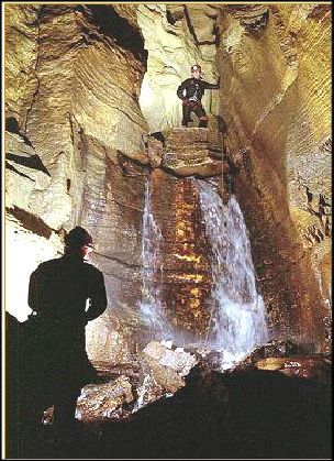
Doug Schmuecker and Larry Welch at Grappling Falls
In 1987 Larry Welch, Bryan Bain (IA) and Stacy Cyphert were able to return to the area. They tossed a grappling hook up the falls, installed a permanent rope, and effectively name the lead Grappling Falls. Through the early nineties, many more trips went through the ear dips to push the leads in upstream WandaÆs via Mud Cayon and up Grappling Falls. The explorers were rewarded with lots of deep sucking mud, more domes, thousands of feet of survey. But all good things come to an end, especially in Coldwater, as breakdown collapse halted exploration progress. On an epic return trip (it now took over six hours to get beyond Grappling Falls) Welch and Jay Wells (IA) probed all parts of the breakdown in search of a way on. Ultimately, they didnÆt run out of possibilities as the wind and water hinted of more cave, but they did run out of steam. It took a number of years for WelchÆs amnesia to kick in but in the year 2000 he returned with latest Coldwater suck-in Ed Klausner (IA), to begin staging another assa ult on Grappling Falls and beyond.
Downstream of the Pig Trough cavers had to work their way through a breakdown maze before getting into going stream passage. Downstream WandaÆs goes as a long, miserable crawlway half-filled with water. This had to be the route that Betty WheelerÆs dye took in 1986 en route to Carolyn Spring. In the year 2000, Welch and John Lovaas were the last cavers to push this lead and reported that it continued on a strong southern trend at relentlessly low and wet dimensions.
In March 2003, Lovaas, Dawn Ryan (WI) and Mike Lace returned to downstream WandaÆs to do a dye injection. Since water levels were low, they hoped to confirm that WandaÆs flows independently and parallel to mainstream Coldwater. Shortly after the dye was injected, warm weather melted enough snow to raise the stream level in WandaÆs Walkway. Dye was detected not only at Carolan Spring, but in all of the downstream infeeders that empty into mainstream Coldwater, and at Coldwater Spring. This illustrated not only the hydrologic relationship between WandaÆs and mainstream Coldwater ¢ it also indicates that there may be passable cave from WandaÆs to Carolan Spring. ItÆs probable that the passage will maintain wet, crawlway dimensions since this part of the cave does cut under Pine Creek. But there is ridge close by which could provide some civilized passage before the ceiling takes the final drop at impassibly low Carolan Spring.
A successful push/survey would add close to a mile of survey to the always growing map of Coldwater Cave. Another trace is planned later this fall with the hopes of confirming that mainstream Coldwater and downstream WandaÆs function independently during base-flow conditions.
Beyond the Spong
Just beyond the Upstream Loop, the mainstream passage hits a series of sumps. The topo overlay shows the cave plot coming out from under Coldwater ridge and heading into a surface valley. The underground manifestation of this is the beginning of the upstream sumps. Access beyond is seasonal and weather dependent making this section of cave a risky endeavor. Winter is usually the best time to hit the area but even then if the temperatures inch above freezing, snowmelt becomes a serious issue. Not only does it raise the water levels, but it lowers the cave stream temperature. Though hypothermia is always a concern in Coldwater Cave, it seems to be bigger and badder beyond the sumps.
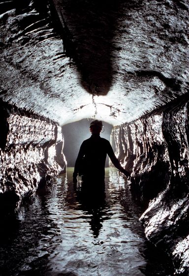
Chris Beck in the Spong SiphonIn 1975, Minnesota caver Ron Spong did the first push on the upstream sumps, the area named in honor of his attempt. With a snorkel and dive line he made it to a breakdown room and another sump. Through the years, a number of cavers tried to penetrate those watery gates either with SCUBA gear which was always a logistical nightmare or with the nose-to-ceiling technique which was plain unnerving; all attempts were unsuccessful.
But a change in perspective fixed that in the mid-eighties when Iowa caver Mike Nelson entered the scene. Nelson thrives on challenging cave and is especially at home in low air spaces. He was strong, fit and unfettered by convention. Nelson took a different approach to pushing the sumps and when he finally found some cavers who could keep up with him (barely), getting beyond the sumps soon became a reality.
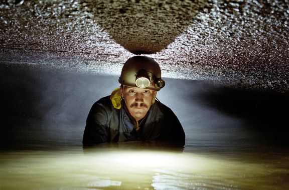
With the low water levels of 1986, Nelson nosed his way, not only beyond the Spong but also past two more low air sections before another total sump was encountered. MikeÆs method of dealing with low air was to lie on his back and cling to the ceiling, pulling himself along at a slow but steady pace so as not to make waves. It was an exercise in psychological control to not get unnerved by the cold water that encroaches on all parts of ones face. Panic would bring unsavory results.
Two weeks after his successful trip, Nelson returned with a ōcavalryö of cavers. Under his leadership, they pushed and mapped nearly 1000 feet of passage to the next ōno airö section dubbed the Scandawhovian Sumps. The sumps looked doable and enthusiasm was high but the spring rains raised the water levels such that even Nelson backed off.
In June of 1987, another window of opportunity presented itself. Nelson, accompanied by cave diver Larry Laine (MN), set out to push the Scandawhovian Sumps. They negotiated 50 feet of low air/no air passage, donning SCUBA gear in a cross joint and continued to another sump (Three Dive Sump). As the name implies it took three attempts before they emerged in new territory. While Laine waited, Nelson explored a lead which he called the Last Right Hand Side Passage. He pioneered over 3000 feet of cave, most of it large-walking sized.
During the 88-89 season, Nelson and his crew hauled tanks up to the sumps and beyond to continue with the survey work. The extra equipment and difficult conditions made for some epic trips. Since the winter was an unusually dry one, Nelson opted for a change in style ¢ rather than using SCUBA to negotiate the sumps, he perfected his face-up approach to low air and passed the technique to the rest of his crew. Working beyond the sumps was now much more efficient without the addition of dive gear. One just needed to be very mindful of the weather, no matter what the time of year, and take absolutely no chances.
The change in style brought many more survey teams beyond the sumps which greatly expanded the northern boundaries of the cave. The main route was pushed west to another sump series where Nelson continued his SCUBA work. Just beyond the Three Dive Sump the north trending Nelson Section goes to an east-west junction. To the west is The Last Right Hand Side Passage (TLRHS) which yielded cave that headed north into high ground and straight for the Iowa-Minnesota border. This, by the way, had been another Coldwater ōlegendö, that some day we would find passage that crossed into the neighboring state just a few miles to the north. East of the junction goes to The Slot Passage ¢ which is pretty much a long crawlway punctuated with some low air and occasionally bits of walking passage. This lead has at least 3 domes at its current limit of exploration.
Mike Lace and Larry Welch led the surveys in TLRHS Passage to an area called the Iguana Crawl, which describes a mode of locomotion and not tropical lizards. Thousands of feet of passage ran by the survey tapes until finally in November of 1989; Coldwater Cave surpassed the length of MinnesotaÆs Mystery Cave, in the ōMystery is Historyö passage. Great discoveries continued to be made throughout the winter and into 1990. The culmination of those trips came at Landmark Falls, a large room containing a roaring waterfall pouring out of a four-foot wide by six-foot high upper lead. This generated much excitement among the survey crews as they prepared to continue the northward assault. But the cave and the weather conspired against further probes into the unknown. The sumps of upstream Coldwater Cave slammed shut for the next 4 years.
But this didnÆt mean that Coldwater cavers had nothing to do. During those intervening years, they were successful in pushing and mapping the ōparallel systemö. The low, grim passages of the upstream loop were further probed and more domes were climbed. The likes of the many downstream infeeders including Guardian Fang, Brothers Grimm, Beaver Boneyard, Toboggan Ride, Sinus Passage, Sand Canyon, First Right Hand side and Monument were explored and graced with the attentions of the survey tape. The Coldwater Cave map continued to grow.
It wasnÆt until early 1995 that the sumps became accessible. Cavers worked on cleaning up the many leads that remained from the initial exploration pushes and in February of that year, Al Berg (IA), Mike Nelson, Larry Welch, Jay Wells, Mike Lace and Andy Christianson (IA) pushed the surveyed length of Coldwater Cave to 15 miles.
From the mid to late nineties, survey teams continued cleaning up leads and Nelson discovered and probed new sumps that headed west. More often than not, the Spong area remained open only for a few trips per year. It was discovered that water levels were not the only thing that could close a sump. Rearrangement of sediment banks and deposition of new ones could locally raise water levels despite favorable water level readings at the entrance shaft.
Finally, starting in 2001, water levels dropped because the groundwater basin was in drought. Survey teams cautiously worked remaining leads, some resurvey was done and Larry Welch started dreaming about Landmark Falls. Was it as good as he remembered from the discovery trip and did that climbing lead go? Welch and Ed Klausner made it back to the falls in December of 2001 and confirmed what Larry had hoped. The lead looked every bit as good as he remembered. The problem would be getting to the top. The climb was overhung, the rock was thinly bedded and brittle and there was a waterfall to deal with. And no one looked forward to dragging their vertical gear through the sump series.
In late 2002 Welch and crew began staging gear for a full-blown climbing assault. Bolting gear, ropes, drills, vertigear and other equipment made it through the sumps and to Landmark Falls. In January of 2003 Welch, Mike Nelson, Charlie Knight (IA), Ed Klausner and Mark Jones attempted the climb. The thin bedded limestone would not take a bolt, and the overhung nature of the falls made drilling awkward and inefficient. The spray of the falls invited hypothermia and the climb was aborted. A cold, dismayed and disappointed group of cavers contemplated the journey out. But while they wallowed in their misery, Jones found an alternate route to the top of the falls that required no bolting. He reported going passage and good air. During the intervening weeks, two more return trips in quick succession added over six hundred feet of north trending cave to the survey. The passage gets smaller and wetter as would be expected heading upstream toward the caveÆs headwaters. That doesnÆt bode well for the ōNorth to Minnesotaö legend. But then again, exploration is 3 and 0 on the other three ōlegendsö.
Exploring and mapping in the Landmark Falls area photo: J. Lovaas
More in Landmark Falls,
photo: J. Lovaas
Future Potential:
On September 21, 2001, Coldwater project members Larry Welch, Mark Jones and Ed Klausner found Coldwater CavesÆ 16th mile at the bottom of ōSweet Sixteenö Dome in a downstream side passage. A few more survey shots began the countdown into the next mile and survey continues to roll in on the third weekend of every month.
Can there be more potential in a cave that has been pushed and mapped for over 28 years? Well, that is the nature of complex cave systems and 20 miles is not out of the realm of possibility. The new frontiers in Coldwater Cave continue to get more challenging. But past history has shown that persistence, ingenuity and a change in perspective have proven wildly successful in expanding the boundaries of the cave.
More survey awaits beyond the upstream sumps though it will take a while to get it all since the cave is fickle on when and how long it will dole out upstream access. The ōparallel systemö, which is also subject to the whims of weather and hydrology, is another good place for more footage though mappers will be spending a lot of time laying flat out in bathtub conditions. There are sure to be more hidden surprises in the way of domes and nickel-and-dime survey in all of the downstream infeeders and in the Upstream Loop. ItÆs all there waiting to be taped by the current and future generations of Coldwater Project cavers.
pppppppppppppppppppppppppppp Cartography: P. Kambesis 2003The Landowners:
Ken and Wanda Flatland own the shaft entrance that was drilled by the state of Iowa. They have been supportive of all exploration, survey and research in Coldwater Cave. In 1975 when the state lease lapsed they welcomed all cavers who wanted to continue exploring Coldwater Cave and they have been unwavering in their support of cavers since then. Those who are not interested in project activities can still get trips into the cave as the Flatlands are proud of and want to share their cave. However, they are concerned with caver impact and safety.
In the 28 years of project caving, the Flatlands closed the cave only once for a three month period in order to re-evaluate cave management and access policies. There had been persistent problems with unintentional formation damage, unnecessary tracking of mudbanks and flowstone areas, incidents with ill-equipped cavers who were unfamiliar with the conditions of the cave and other related problems. Project work continues uninterrupted and exploration or other project objectives can be scheduled for any weekend as needed. But tours of the cave must be led by an experienced guide and scheduled during the projectÆs third weekend of the month trip. This is to insure the safety of both the cave and the cavers. The third weekend rule assures that should there be any problems; a core of experienced cavers would be available on hand to respond immediately.
To the Coldwater Project, the Flatlands are more than landowners; they have become friends, peers and mentors. In the early days of the Coldwater Project it was not uncommon for them to invite 8-10 hungry cavers to their home for Sunday breakfast. They annually host a special Coldwater weekend picnic in June where cavers and their families can enjoy a weekend of good food, cave tours and a traditional bonfire. During the big pushes on Landmark Falls early 2003, Ken Flatland came down to the field house to stoke up the stove so that the building would be warm for cavers returning in the wee hours of the morning, and Wanda made up a pot of chili to feed the hungry group. These are just some of the things that the Flatlands have done for cavers over the years and the work in Coldwater Cave could not have been accomplished without their support and participation. We are proud and privileged that they consider us ōpart of the familyö.
The Coldwater Cave Project is an official project of the NSS.