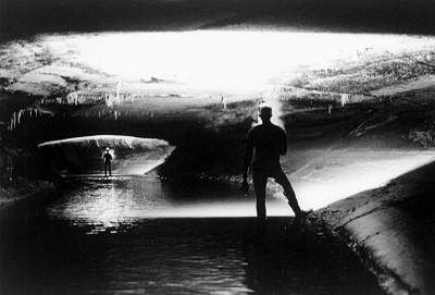
Word of
Coldwater's status traveled fast in the local caver grapevine. Neil Saylor of
the Minnesota Speleological Survey (MSS) took a fervent interest in Jagnow and
Barnett's caving exploits. With information he garnered from past trip
reports, the IGS Coldwater Study, and his extensive surface checking, he saw
three areas of exploration potential.
Saylor observed from his field checking excursions that he was unable to
follow the route of the water in the many sinkholes that drained land directly
above the cave. The existence of numerous domes that feed water into
mainstream Coldwater via unpushed upper leads caused him to postulate the
existence of an extensive upper level. A sinkhole plain east of Coldwater
drains a large surface area under which there was no known cave. That, coupled
with Barnett's report of crossing a drainage divide in an eastern downstream
side passage, raised the possibility in Saylor's mind of a parallel extension
to the main stream. Finally, the fact that most of the water in Coldwater
originates beyond the terminal upstream sump was indicative of more passage
upstream and beyond.
In early 1975, Saylor approached the landowner about the possibility of
cavers continuing to explore and map Coldwater Cave, emphasizing that the cave
still had potential. Ken Flatland was amenable to the idea and granted the MSS
access to the cave.
During that year Saylor led MSS cavers in a dual quest: pursuit of the
speculated upper level and penetration of the upstream sump. They made several
attempts to reach the upper lead in the Waterfall Dome, but were unsuccessful
in negotiating the climb. Ron Spong, taking advantage of low water levels,
braved the upstream siphon surfacing in a large breakdown room. He traversed
the room and encountered another sump. Since he was alone, he felt it prudent
to terminate his exploration.
After several unsuccessful and frustrating upstream trips, MSS cavers
elected to concentrate their efforts in the eastern side passages downstream
from the shaft. They explored the Monument Passage and mapped and connected
the Well Pipe and Cascade Creek Passages. With white faced trepidation they
reported on how suddenly the water rises in the Cascade Creek Passage in
response to rain. They also noted that the Monument Passage, the only
downstream passage that doesn't feed the mainstream, appears to direct water
away to some unknown destination.
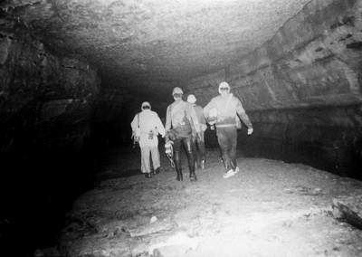
Other cavers also became interested and were allowed access to Coldwater
Cave during 1975. Saylor played the classic suck in, casually dropping hints
about upper levels, parallel systems, and upstream borehole. This tactic
inspired Iowa Grotto members to do several reconnaissance trips to the cave,
and in November, Rock River Speleological Society (RRSS) became interested in
starting a grotto survey project. With Ken Flatland's blessing and Neil
Saylor's direction, the group opted to work the upstream section of the cave.
RRSS resurveyed sections of the mainstream from the shaft to the upstream
sump and pushed and mapped the Snake Passage. Accompanied by cavers from Iowa
Grotto, Wisconsin Speleological Society and Windy City Grotto, they surveyed
the Waterfall and Pete's Pipe Passages discovering that the two connected.
On some trips people noticed that they shared symptoms of indigestion,
headache, and breathlessness. At times carbide lamps burned "funny," and a few
trips were cut short because the participants felt bad physically. Doc Lewis
concluded that they probably suffered from the high C02/low 02 levels and
prescribed downstream trips or surface reconnaissance for those weekends when
the high levels were suspected.
In the spring of 1976, an upstream exploratory crew discovered a dome 150
ft from the Waterfall Dome containing what appeared to be a walking height
upper lead. Could this be Neil Saylor's upper level? In anticipation, it was
named Gateway Dome. Rock River cavers designed and built a climbing pole, and
in July of that year dragged it nearly 11/2 miles upstream to push to dome. To
everyone's disappointment the passage ended in unstable breakdown after a few
feet. Several more unsuccessful assaults were launched on the Waterfall Dome
and finally, in 1978, WSS cavers completed the climb, reporting a small
crawlway blocked by breakdown.
During the fall of 1976, RRSS members Tom Backer, Pete DeVries, Duke
Hopper, Dave Smith, and R.C. Schroeder made two trips beyond the first
upstream sump, emerging in the breakdown room that Spong of the MSS had
described. They surveyed through a low air section, popped out in a second big
room and mapped to another low air lead (The Tuna Sea). Schroeder cautiously
inched his way in a 3.5 inch air space water crawl to a cross joint beyond
which the passage appeared to sump. Total surveyed distance was 1100 ft.
The marginal air space encountered in the upstream sump along with
fluctuations in water level dependent on surface weather conditions made
passing the upstream sump a dangerous proposition. Because upstream potential
seemed so probable, cavers looked to the grim little tributaries feeding the
Waterfall Passage. They speculated, based on the Waterfall Pipe Passage link,
that a connection was possible between the Waterfall Passage and upstream
beyond the Tuna Sea. A core group of RRSS cavers (Bruce Coulter, Pat Kambesis,
Brad Olson and Mark Rohn) spent over a year conducting a systematic survey of
the west trending crawlways off the Waterfall Passage. They mapped hundreds of
feet of low, muddy passage, but found no bypass.
Their last hope lay in the Obstruction Passage, another sleazeway supreme
that blew lots of air but where exploration was stymied by a 4 foot long
flowstone blockade. There was a narrow space between the ceiling and the
obstruction which looked almost impossible for human penetration. Numerous
attempts and various methods were made to enlarge the window over the
blockade. Finally, small cavers, willing to remove their wetsuit tips,
squeezed through the "window" to the other side: bigger cavers, agreeable to
being bodily pushed/pulled, were stuffed through the hole. The several trips
that ensued found nearly 1000 ft of flat out belly crawl (with no end in
sight) and a wind that chilled them to the bone. One last major push was
attempted by Pat Kambesis and Philip Moss in the summer of 1980. They noted
the absence of air movement and suffered mild effects of high C02 levels.
Perhaps the entrance to the connection route beyond the Tuna Sea had silted
shut during the spring floods.
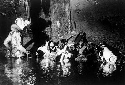
Cavers continued to push leads in the upstream domes with little success.
Passages at the top were either too small for human entry or were filled with
breakdown. In early 1979, RRSS made a final attempt on the upstream sump,
enlisting the help of a group of newly certified cave divers. The divers,
expecting Florida water conditions and worn out by the long trek to the
upstream lead, never made it to the Tuna Sea.
With interest and enthusiasm in upstream Coldwater at low ebb, the project
gradually shifted focus downstream. Coldwater project members resurveyed the
main passage from the entrance shaft to the downstream sump. Upstream cleanup
surveys alternated with downstream reconnaissance trips to the Cascade Creek,
Well Pipe, and Monument Passages. Mapping commenced in smaller downstream
leads and several domes near the entrance shaft received concentrated climbing
pole attention. The upstream sumps took low priority to the continued search
for the evasive upper level.
As of 1980, there were 7 miles of surveyed passage in Coldwater Cave with
additional known cave that wasn't on the map. In an effort to increase survey
footage, they concentrated on finishing off incomplete areas and rechecking
old leads.
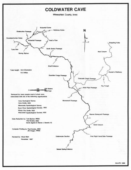
Of particular interest was the Cascade Creek Passage where MSS cavers had
surveyed 3/4 of a mile and left some unchecked leads. The passage was
intriguing in that, during the winter, water flowing from it seemed to run a
little colder than the rest of the main stream. Water levels responded quickly
during floods and air flow was good. Subsequently, what started as a cleanup
survey turned into one of the most significant discoveries in Coldwater Cave,
fulfilling another Neil Saylor prediction and adding nearly 2 miles of passage
to the map.
Over a number of trips, Gary Engh, Barry Shuman, Cbuck Rex, John Moses,
Glenn Glasser and others explored and remapped the Cascade Passage. They
discovered bats in a cross joint off the main stream Cascade a first in
Coldwater Cave, and perhaps an indication of another entrance in that area. A
sleazy side passage before the bat cross joint was dubbed the Pig Trough, it
later proved to be an important area in this section of cave. As the survey
progressed in Pig Trough, cavers breached a drainage divide which broke into a
parallel drainage system named Wanda's Walkway. A downstream push found sumped
passage via a tangle of breakdown and deep water. The upstream route yielded a
series of domes and crawls which led to a junction room (the Roundhouse)
measuring 40 ft long, 25 ft wide, and 7 ft high. Five passages lead out of the
room like spokes from a hub.
Cavers pushed a north trending lead out of the Roundhouse to Mud Canyon,
600 ft of mushy meandering mudbank passage. As the group progressed upstream,
mud became less of a problem and passage decoration appeared, then increased
in density. Squeezing through a near choke of formations and traversing
another 300 ft, they discovered a large 80 to 90 ft high dome room. A
waterfall poured out from a walking height lead 10 ft up the wall.
Using some webbing, Gary Engh lassoed the lip and negotiated the tenuous
climb. Upon reaching the top he could see virgin passage. He could also see
that the webbing was marginally supported by a jumble of big, unstable
breakdown. Gary felt that the dangerous nature of the breakdown, coupled with
the insufficient webbing rig, made further progress too risky at that point.
In spite of the promising lead, the long, strenuous trip required to reach
this remote area proved to be a near endurance barrier for many cavers and
interest temporarily waned.
Like many long term caving endeavors, the Coldwater Project went through a
period of stagnation. Several good cavers left the area and interest and
motivation went into remission. In spite of this, people continued to meet and
go caving on the third weekend every month.
Continued Exploration in Wanda's Walkway and the Upstream
Sumps
Another trait of long-term caving projects is that a little new
blood is all that is needed to spark enthusiasm and renew activity. New cavers
to the project began working bring interest back with the help of some of the
remaining "old timers."
Mapping trips to the many small, miserable side passages slowly increased
total survey footage. Digging projects were initiated in Sand Canyon and
Monument Passage. New leads were noted and old ones were scrutinized with new
enthusiasm. In December of 1986 Dave and Sue Ecklund led a survey trip into
Guardian Fangs Passage, bringing the total surveyed footage to 10 miles; a
goal accomplished by the cumulative hard work of many cavers over the past 19
years.
Gary Engh, Larry Welch, and Bryan Bain returned to Wanda's Walkway in the
spring of 1987, equipped with a collapsible grappling hook and tossed it into
the upper level waterfall lead, which was subsequently called Grappling Falls.
Logistical problems postponed the ascent to a later trip on which Bain was
successful in reaching the upper lead and bypassing the unstable breakdown.
Big virgin passage led away from the top of the waterfall and over massive
breakdown for several hundred feet to the source of the water; a 4 ft wide by
2 ft high slot that moved plenty of air an excellent indication of more cave
passage and a push left for another trip.
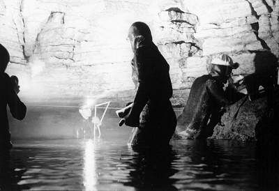
Iowa Grotto cavers tried their luck at the Spong Siphon, making two
unsuccessful attempts in late 1985. Mike Nelson, undeterred by the results of
the previous trips, grew fascinated and then obsessed with what lay beyond the
upstream sumps. The low air space so characteristic of the area intimidated
most cavers and usually "wetted down" their interest after a first trip.
Nelson, who seems to thrive on ear crawls and intimate nose to ceiling
contact, has been the driving force in current upstream exploration.
At about the same time that interest was renewed in the upstream sumps,
Betty Wheeler, a graduate student at the University of Minnesota, began
conducting a series of dye traces. Rhodamine dye, which was introduced on the
surface upstream from the Tuna Sea, rapidly found a way into the cave and
inspired another round of Tuna Sea fever.
The low water levels of January 1986 allowed Nelson to nose his way through
Spong Siphon to the first cross joint in the Tuna Sea and beyond R.C.
Schroeder's farthest point of penetration. He traversed approximately 300 ft
of 3 6 in air space through a series of cross joints and rooms to "Beyond the
Tuna Sea" After another 300 ft of virgin passage, he turned back. Excited and
doubly determined, he returned to the surface to instigate plans for a full
scale exploration and survey trip.
Two weeks later, he returned to the site with a group of seven Iowa Grotto
cavers. They pushed and mapped nearly 1000 feet of passage to Scandawhovian
Sumps and noted a pyramid-shaped side passage that also sumped. Spring rains
reinstated the normally high water levels and it was 11 months before the
water dropped enough to allow further exploration.
In early 1987, Nelson launched another trip upstream where he did a belayed
free dive reconnaissance of the Scandawhovian Sumps, finding going passage
beyond them. However, the big breakthrough came in June of 1987. Nelson,
accompanied by Minnesota cave diver Larry Laine, set out to push the
Scandawhovian Sumps. They negotiated 50 ft of low air/no air passage, donning
SCUBA gear in a cross joint and proceeded to another sump (Three Dive Sump).
As the name implies it took three attempts before they emerged in new
territory. The route forked farther upstream and they chose the north trending
lead.
A tight horizontal squeeze opened to a small room, then a hands and knees
water crawl, and finally stoop walking passage. Laine waited here while Nelson
continued to explore. Passage dimensions enlarged to walking size and he found
two large rooms, a breakdown area, and some promising leads. Realizing that
they were overdue on the surface, the two retraced their steps, pacing off
3000 ft of new passage.
A return trip in July included Mike Nelson, Dave and Sue Ecklund, Bill
Nelson, and Doug Schmeucker. The group mapped 450 ft in the south fork to the
"End Again Sump. " Mike probed the sump with his feet and found air on the
other side. However, a dive was not attempted at that time. Several promising
dive leads and a side passage lead still remain to be explored and mapped on
future trips.
In summing up the upstream explorations, Mike says, "Though this area will
be inaccessible to the faint of heart or those with any phobias about water,
promising leads still exist in this, Iowa's biggest and still growing cave."
|
EpilogueAfter 20
years, Coldwater Cave continues to give just enough to keep cavers coming back for more.
Wanda's Walkway carries a
significant amount of water and has entered a major ridge. The lead beyond
Grappling Falls awaits cavers with the endurance and determination to make the
trip.
The large downstream dome with the big upper level lead discovered by Steve
Barnett and Larry Fattig during an early exploration trip has never been
revisited. The upstream sumps offer virgin passage to those who enjoy the
proverbial ear crawl. In this area on the surface, the cave has almost
penetrated a ridge that extends into Minnesota and toward a large sinkhole
complex southwest of the town of Harmony.
Mike Nelson reports that beyond one of the upstream sumps, passage trends
south, a real enigma for this area of the cave where everything else seems to
be heading north.
In December of 1986, cavers used a specially modified cable ladder with a
hooking pole to gain access into an upper level fissure passage; the quest for
the upper level continues.
The promise of an upper level, an intriguing parallel drainage system and a
major extension beyond the upstream sump continue to motivate cavers today as
in the past. However, the most important factor that has been instrumental to
the work being done by the Coldwater Project is the excellent relationship
between the landowners and the cavers. Ken and Wanda Flatland understand the
significance of their cave, appreciate its beauty, and are aware and willing
to preserve it. They realize that the cave should be protected, but do not see
the need to restrict access from responsible people. Their enthusiasm toward
the cave matches that of the cavers involved, and it is with this
encouragement and support that the Coldwater Project continues. |
pppppppp
Cartography: Atkinson & Kambesis 1988 |
AcknowledgmentsIn addition to those cavers mentioned in the
article, the authors would also like to thank the following people for their
contributions to this article, the Coldwater Cave Project, or both: The
Flatland Family, Mike Bounk, Lowell Burkhead, Stacey Cyphert, Dave "Chainsaw"
Devries, Pete DeVries, Dave and Sue Ecklund, Dave Jagnow, Jim Klager, Mike
Lace, Dr. Warren Lewis, Mike Nelson, Jeff Plache, Frank Rose, Paul Scobie and
Larry Welch. So many other cavers have been involved over the years that,
unfortunately, numerous names were omitted. This does not mean that these
people are insignificant or forgotten. We salute all Coldwater cavers who have
struggled into wetsuits since the discovery, 20 years ago.