A HISTORY OF
THE EXPLORATION AND SURVEY |
pppppp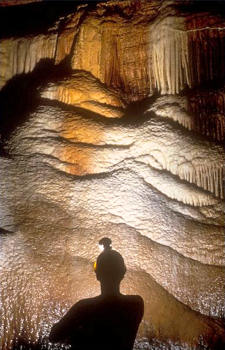 |
A HISTORY OF
THE EXPLORATION AND SURVEY |
pppppp |
Coldwater Cave, Iowa's longest and most spectacular cave is located in the Coldwater Creek Conservation area, Iowa's northernmost and least known park. The size of the active stream passage is unique in Iowa, a state in which most caves are short muddy crawlways, for to date there are approximately 11 kilometres of surveyed passage and potential exists for more. Coldwater has some of the most beautiful and impressive formations found anywhere, including its series of six-metre by eight-metre-long pure white flowstone-covered buttresses located in the Gallery Section of the main stream passage.
Coldwater Cave was discovered in Fall of 1967 by Steve Barnett and Dave Jagnow, two Iowa Grotto members, who had been investigating springs in Winneshiek County for cave potential. They noted that Coldwater Spring issues a large volume of water from the base of a limestone bluff. They had also heard stories from the local people about the existence of enterable cave passage in the bluff, which a farmer supposedly blasted shut because he had lost livestock there.
In September, 1967, Barnett, wearing only a face mask, attempted to dive the 9 degrees Centigrade spring. On his second try, he entered a room approximately six metres long, two metres wide and five metres high, which siphoned at the opposite end. He made voice contact with Jagnow at the surface. On their next attempt, the two negotiated a series of sumps totaling 400 metres finally emerging into a walking-height stream passage. As they walked upstream, they saw several large side passages.
The stream varied in depth from one metre to where it was over their heads. The main stream passage averaged seven metres high by eight metres, across. Barnett and Jagnow explored upstream for 850 metres on this trip.
On their third trip, Barnett, Jagnow and Tom Egert of Little Egypt Student Grotto, Illinois, explored upstream from the siphon for five kilometres on a trip lasting over thirty hours, They passed several large breakdown areas, additional walking-height side passages, and the Gallery Section, a highly decorated area about four kilometres from the spring entrance. This section of the cave contains several large flowstone buttresses along with many stalactites of varying sizes and shades from black to red to white. They ended their exploration just beyond a large breakdown area on a mudbank, later to be called the Jumping Off Point.
In June of 1968, Barnett and Jagnow completed a 52 hour survey trip, mapping from the spring entrance to an upstream siphon, a total of five and a half kilometres. The main passage beyond the Jumping Off Point was considerably lower than what they had encountered previously; one metre or so. The stream averaged knee-high with a layer of sticky mud on the bottom. They encountered two side passages, the first of which, the Pipe, was not entered. The second, the Waterfall Passage, was surveyed 45 metres to a dome. Barnett then explored the passage 880 metres to an upper level waterfall dome, noting a passage near the top which would require bolting. On the way out of the dome his lamp went out and, unable to relight it, he found his way to Jagnow in the dark.
On these long trips, Barnett and Jagnow tried using space blankets and plastic sheets in order to keep warm enough to sleep. Nothing really worked well and often they woke up shivering. The prolonged periods in long underwear and full wetsuits resulted in severe skin abrasions and sores. Needless to say, the marathon trips were physically and mentally exhausting.
On their next several trips, Barnett and Jagnow explored and photographed most of the downstream side passages. They did surface work, checking sinkholes for another possible entrance, but with no luck.
The duo had been secretive about their find, not telling the landowners in the area of the cave's existence. Some of the landowners were suspicious of Barnett and Jagnow walking over their land, so they called in cavers from the Minnesota Speleological Survey (MSS). The MSS spent almost a year checking land, totally unaware that they were walking over Coldwater Cave. There were few features for them to note, however, because the cave is deep, 28 metres from the surface at its shallowest point, and the karst features are undefined due to the glacial debris in the area. To this date, a natural surface entrance has not been found.
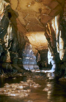
Pothole Country, downstream Coldwater Cave. Photo: M. Bounk
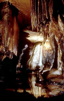
The Gallery, downstream Coldwater Cave. Photo: M. Bounk
In December, 1969, Barnett and Jagnow presented their find to the Iowa State Conservation Commission. Shortly thereafter, The Des Moines Register published an article by reporter Otto Knauth titled, "How Iowans Risk Lives to Find Huge Cave," replete with color photographs. This article constituted the first notice of any kind of the cave's existence.
On subsequent trips, Barnett and Larry Fattig dove a 35-metre sump at the end of one of the downstream side passages, reporting a dome approximately six metres in diameter, the top of which could not be seen, and with a subway-sized passage about six metres up the wall. Barnett reported crossing over a drainage divide while exploring a crawlway in another downstream side passage and in 1970 Fattig and Loren McVey explored about 300 metres into the previously unentered Pipe, thinking it was the Waterfall Passage.
At the end of December, 1969, Iowa Grotto members designed a gate for the spring entrance to the cave. It was manufactured for the Iowa Conservation Commission and installed by Iowa Grotto members in May, 1970. At that time Jagnow and Al Swenson made one last trip through the siphon to take pictures of the Gallery section. On their way out, they locked the gate and turned the keys over to the Iowa Conservation Commission.
Because of the cave's unique features and potential for commercialization, the Iowa Legislature appropriated $58,000 to study the development of the cave. From Barnett and Jagnow's survey, the state plotted the cave and contacted area landowners concerning leasing land and drilling a shaft entrance. At first, the state had problems getting cooperation from the landowners who were upset because no one had advised them of the existence of the cave until now. Finally on June 4, 1971, Ken Flatland, a local dairy farmer, entered into a lease agreement with the State of Iowa to permit exploratory drilling and to construct a shaft, shed and access road, in order to evaluate the cave for state acquisition as a recreation or preserve site.
Based on the Brunton and tape map by Barnett and Jagnow, the state drilled to pinpoint the cave's location in February, 1972, and on the third attempt penetrated an inderground void. The void was investigated by camera to msure that speleothems would not be damaged by ,onstruction of a large-diameter shaft. Subsequently, the state drilled a shaft and installed a steel casing and aluminum ladder with a wooden platform at the base of the ladder. Also, the state erected a building over the shaft and enclosed the site with a cyclone fence.
In December, 1972, a team of biologists sampled the flora and fauna of the cave for documentation prior to the possible entrance of large numbers of people. On January 22, 1973, Barnett and McVey showed the cave to Don Koch and Dr. Samuel Tuthill of the Iowa Geologic Survey, and on the following day the group accompanied a number of reporters on a press trip, which included exploring a few hundred metres of the Snake Passage, located 150 metres upstream from the shaft. This was the last trip in the cave by Iowa Grotto members until the state's lease expired in January of 1975.
For the next two years, the State of Iowa, employing explorer scouts instead of cavers, conducted a theodolite and subtense bar survey of one and a half kilometres of the main stream passage and part of the Well Pipe passage, so called because in it is a metal well pipe sunk from the surface. The survey was thus able to correlate the cave with surface features. Also during this period, scientists conducted studies on the composition of the air and water, temperature, the fauna and flora of the cave, dating of cave formations, and chemical, bacterial, paleontology and palynology studies. In addition, consultants investigated the possibility of commercial development of the cave and discovered several problems. Coldwater is a deep cave and to get visitors in and out would require mechanical means-an elevator; the air is cold and damp so adequate clothing would be necessary; all the known decorated passages are stream passages and the water levels fluctuate with the outside precipitation, thus requiring expen sive walkways to be built above the stream level; a waterproof lighting system would be a necessity; and lastly, since the cave does not lie on a major highway or close to developed recreational facilities, it is not easily accessible to the public. In 1974, the Iowa Conservation Commission published all its findings in an official report in which it was estimated that the cost of commercial development would be well over a million dollars.
In 1973, Jack Leonard, noted photographer, made a movie in the cave which was shown on Iowa television stations. The governor of Iowa made a broadcast from the platform at the foot of the shaft. Although the cave generated tremendous enthusiasm, the state could not justify a large expenditure for commercial development at that time. The State of Iowa thus allowed its lease with Flatland to lapse, and in January of 1975, the cave and the improvements were turned back to the landowners.
After hearing that the lease had expired, Neil Saylor of the MSS contacted the Flatlands regarding furthering the survey of Coldwater Cave. The MSS started exploring upstream from the shaft, making several trips to the dome at the end of the Waterfall Passage. The dome can be climbed three fourths of the way up, but the last metre to the passage is too treacherous without climbing aids.
Attracting Saylor was the possibility of an upper-level passage and he felt that access could be gained to it via the Waterfall Dome. The group tried bolting the dome but managed to get only part way up. The length and nature of the trip to this dome makes it difficult to complete work there, because the Waterfall Passage itself is a little over a kilometre of crawling on hands and knees with the last hundred metres a bellycrawl, so that by the time anyone reaches the dome most are simply too tired to work. The 80C waterfall, the continuous cold breeze in the dome, and the restricting wetsuits all, of course, add to the misery.
The MSS knew from the 1974 Iowa Report that seventy per cent of the water flowing out of Coldwater spring derives from upstream of the shaft. Some of the upstream water that feeds the main stream comes from the Pipe and the Waterfall Passages, but most comes from beyond the upstream siphon, indicating that there is more cave beyond that point. In February, 1975, MSS member Ron Spong dove the upstream siphon by himself using only a mask and snorkel, surfacing into a large breakdown room which continued. Since he was alone, he did not go further. During the course of the year, the MSS concentrated its efforts on exploring and mapping the downstream side passages.
Iowa Grotto members made three trips into Coldwater in 1975. On the first two trips, they explored portions of the main stream downstream from the shaft and explored the Waterfall Passage. On their third trip, accompanied by Jeff Burkett and Duke Hopper of Rock River Speleological Society (RRSS), the group went as far as the Jumping Off Point and then headed for the spring entrance. Burkett and Hopper, who exited the cave after a few hours were surprised hat so much cave remained unsurveyed and that virgin cave still existed. In January, 1976, RRSS returned to the cave to determine the possibility of making a club project out of finishing the unsurveyed leads.
In February, 1976, after consulting with Neil Saylor, RRSS started its own survey of the upstream section, with the MSS continuing its work downstream. On the third weekend of every month for the next three years, RRSS made monthly trips to the cave, oftentimes accompanied by members of the Iowa Grotto and the Wisconsin Speleological Society (WSS). The group resurveyed the main stream from the shaft to the upstream siphon; they mapped the Pipe Passage and all the side passages in it; they surveyed the North Snake Passage; and they finished the Waterfall Passage with all its side passages. In spring of 1976, an exploratory crew discovered a dome several hundred metres from the Waterfall Dome containing a walking-height upper level lead. Could this be Neil Saylor's upper level? In anticipation it was named Gateway Dome, a gateway to the upper level. The RRSS designed and built a climbing pole, and in July of that year dragged the pole nearly three kilometres upstream and set it up in the dome. To everyone's disappointment the passage ended in unstable breakdown after a few metres.
In Fall, 1976, RRSS members Tom Backer, Pete DeVries and Duke Hopper nosed their way past the upstream siphon, which had eight centimetres of air space due to a drought that summer, and came out in the breakdown room that Ron Spong of the MSS had described. They were forced to return after noticing debris floating in the water, an indication of rain. However, a team consisting of DeVries, Hopper and R.C. Schroeder returned a few weeks later and surveyed 330 metres beyond the siphon, discovering another large breakdown room and encountering another siphon.
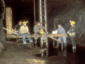
The platform beneath the shaft entrance of Coldwater Cave. Photo: M. Bounk
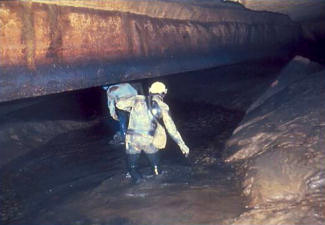
The Jumping Off Point, Upstream Coldwater Cave.
Photo: Dr. Warren Lewis
Since passing the first siphon was such a dangerous proposition, members of RRSS started looking for a side passage that might bypass the siphons. They explored and surveyed all the side passages heading west off the Waterfall Passage, saving its most promising lead, the Obstruction Passage, for last because of the difficulty of passing a large flowstone block obstructing the passage. A previous group that had surveyed the area noted considerable air movement there. This could be the anticipated overflow route of the main stream. After many months of trying to enlarge the passage, one small caver, the author, was able to bypass the obstruction. Because of flash flood warnings and because I was alone I explored for only 60 metres. In summer, 1977, a survey team made up of small, skinny cavers returned to map the passage. Since only two of the team members, Bruce Coulter and I could squeeze past the obstruction, we explored, instead of surveyed, for about 450 metres. The passage was extremely low and wet and we had to travel flat on our stomachs for the entire distance. Nowhere was there even a place to sit ap. The intense air movement in the passage flickered our !ights. We were sure the passage would open up just around the corner but it never did. Exhausted by the unexpected long crawl, we turned back. In August, Coulter and I returned with Steve Barnett and J.J. Erickson of the Iowa Grotto to try the passage again, optimistic that this time we would find ourselves in the main stream. We crawled for over 760 metres until the ceiling dipped several centimetres, making further progress impossible. We did note that if a channel could be dug for a few metres the crawl could be continued since the ceiling rose again. Once more taunted by the wind, we were forced to turn back.
In 1977, RRSS members made unsuccessful trips to several domes in the cave utilizing the climbing pole. The passages at the top of the domes were either too small for human entry, though they did carry water, or else were filled with mud or breakdown.
In 1978, WSS members successfully bolted the Waterfall Dome. The passage at the top was traversed for 25 metres but became too constricted for anyone but a very small and skinny caver. After a few clean-up trips upstream, the RRSS moved its efforts downstream to the walking-height passages. It discovered several domes just off the main stream in the shaft area, all of which were climbed, but without success. Also, the RRSS resurveyed many of the side passages that the MSS had originally completed since it was conducting its own survey with different objectives.
In 1979, the RRSS assisted four certified Scuba divers in another attempt on the upstream siphons, but the attempt was unsuccessful. After this the RRSS split its efforts between surveying leads downstream and climbing pole trips.
To date, with over 11 kilometres of surveyed passages, most of the leads remaining in Coldwater Cave are low and muddy. No one has found the dome with the subway-sized passage or the drainage divide area which Barnett described. Most have given up any hope of finding an enterable upper-level passage; surface work has been slow and unrewarding due to the depth of the cave, which makes correlating surface features with the cave difficult. The one promising lead is the upstream siphon area; since this is the source for most of the water, more cave passage probably exists there. However, to Scuba dive the siphon requires dragging the gear almost two kilometres in passage which is one and a half metres in height. The Obstruction, with its air movement, probably does bypass the upstream siphon area, but one would have to bellycrawl for more than 700 metres before re-entering the main stream. Further, most cavers cannot fit through the small space over the obstruction, and besides would have to drag an entrenchin g tool on the long crawl to enlarge the passage for further exploration.
All in all, work in Coldwater Cave has been slow, tedious, and hard for the groups involved. On the positive side, the cave has brought together cavers from several different areas. They have worked closely together and have learned much from each other.